The San Juan Skyway – The Other Back Road in Southwest Colorado.
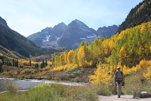
Nothing beats Colorado when it comes to Scenic Byways and back roads. On a recent bluebird fall day, we set out to drive the San Juan Skyway, which winds its way through one of the highest mountain ranges in the U.S. ----the San Juan Mountains.
Colorado has ten Scenic Byways, but none is quite as spectacular as our 232 mile drive loop, the San Juan Skyway. We began our adventure in Durango, home to the historic Durango to Silverton Narrow Gauge Railroad an original 1880’s narrow gauge, with authentic rolling stock from the mining days. Remember the narrow gauge is three and one half feet, not the standard track.
Durango is ground zero for exploring the rich mining heritage and 4 WD drive roads of the San Juan Mountains, hiking the Weminuche Wilderness & the Colorado Trail and discovering the cliff dwellings of nearby Mesa Verde National Park and Hovenweep National Monument. Durango’s rockin and rollin’ night scene includes some of the Centennial State’s most innovative restaurants and brew pubs including Ken and Sue’s, the elegant Mahogany Room in the 1890’s Strater Hotel, and Asian Fusion restaurant East-by- Southwest. Drink up. Stick a chopstick into a Ganja Mahnn Roll. We noted that the locals call Durango the City of Brewerly Love because of the number of brew pubs which do a robust business here.
Durango’s awesome Animas River hike and bike path runs through town and on the North end of Durango, hang out in the soothing Trimble Hot Springs. There’s the fascinating Durango Discovery Museum----one of the earliest coal-fired alternating current (AC) electric plants in the world. We marveled at this power plant long abandoned on a blighted brown field next to precious downtown riverfront property. Today, restored to its handsome 1893 architecture, its vision is all about power and knowledge for the future.
Durango is where a Fall Color Journey begins. We followed Highway 550 north, the route of the legendary Iron Horse Bicycle Classic from 6700 feet in Durango over Coal Bank Pass and Molas Divide to Silverton at 9300 feet. Held annually on Memorial Day Weekend, cyclists attempt to complete the 49.1 mile / 6650 feet elevation gain in less time than it takes the train to get from Durango to Silverton. The best time by a cyclist in the 40th Annual Iron Horse Bicycle Classic was two hours and eighteen minutes climbing over the two mountain passes and descending into Silverton.
A National Historic Landmark, Silverton lies in a steep mountain valley and was founded in 1874 at the height of the mining boom. Its dirt streets are graced by Victorian hotels, homes and former sporting houses built by the hardworking miners and mine owners who hauled out millions of dollars of gold and silver ore from this area during the late 19th and early 20th centuries.
After visiting one of Silverton’s famous bordellos, Natalia’s 1912, for lunch, hiking up to the Christ of the Mines Shrine and lingering over gravestones in the Silverton Cemetery, we began climbing the Million Dollar Highway section of the San Juan Skyway from 9300 feet to 11,008 Red Mountain Pass. This white knuckle section of the San Juan Skyway climbs past the Most Dangerous 4 WD Road in Colorado, Black Bear Pass, past iron-colored Red Mountain, the ghost towns of Ironton and Guston, finally switchbacking down the precipitous Uncompahgre Gorge past waterfalls, steep 4 WD roads like the Alpine Loop, snow sheds and bridges over rushing mountain creeks and Ouray’s Box Canyon Falls. We pulled out at an overlook before the Amphitheater campground and gazed down at Ouray, a National Historic District, known as the Switzerland of America. Ouray is named for Ute Indian chief and peacemaker, Chief Ouray who led his tribe here to soak in the soothing hot springs and undertake medicinal cures in the waters. We did the same relaxing and spending time in the Ouray Hot Springs pool and in Orvis Hot Springs, 10 miles North of Ouray. Orvis is clothes optional so bear this in mind if you’re shy. Other options in Ouray include hiking to Lower and Upper Cascade Falls, a huge waterfall overlooking the town.
From Orvis, we headed to Ridgway at the junction of Highway 550 and Colorado 62. We stopped for lunch at Thai Paradise, a new and beyond delicious Asian restaurant that had diners lined up at its doors. And then it was West on Highway 62 towards Dallas Divide, passing the Double RL ranch owned by Ralph Lauren. At Dallas Divide, we stopped to admire Mt. Sneffels (Sneffels means snowfields in Norwegian), Mt. Kismet and the surrounding Mt. Sneffels Wilderness which has been proposed to be a part of the San Juan Wilderness. We remembered climbing to Blaine Basin underneath the North Face of 14,148 foot Mt. Sneffels, but today’s journey was by Ford rather than foot.
Rolling down valley to the junction of Highway 62 and 145, we ascended Bondad Hill, after driving through the tiny communities of Placerville and Sawpit, on our way to Telluride --- famous as one of the West’s Steeps and Deeps Ski resorts. Course, in summer there’s Telluride Blues and Brews Festival and Telluride Film Festival. But Telluride’s nineteenth century history is the back story. It was the site of the first bank robbery by Butch Cassidy and the Sundance Kid along with the Wild Bunch, June 24, 1889. It’s also home to the Imogene Pass 4 WD road from Telluride to Ouray, only 20 miles of terror on shelf roads with steep descents and ascents, the road goes right through the Tomboy Mine site, with its old head frames, mining equipment and saloons.
Telluride is home to one of the first Alternating Current Power plants in the world perched high above the narrow valley at the precipice of Bridal Veil Falls. The other cascade at the end of this box canyon is Ingram Falls and Bridal Veil Falls. A steep 4 WD road take the jeep driver to the top of the Falls, or you can hike it, if you want a great workout, it’s only four miles and 1650 feet of elevation gain to the top. As we left Telluride heading south on the San Juan Skyway, we passed the tiny, historic town of Ophir and its scenic Ophir Pass 4 WD road heading back over Ophir Pass to Silverton.
Ahead of us, was Lizard Head pass and the rotten rock, volcanic cone of Lizard Head Peak. Behind Lizard Head are three 14, 000 foot peaks that climbers try to scale every August when the snows are gone: El Diente (The Tooth), Mount Wilson, and Wilson Peak. Alongside the San Juan Skyway, way posts tell the story of the Rio Grande Southern Railroad ---tracks in time that traveled this route until 1952. Descending from the summit of Lizard Head Pass, we took the steep dirt road that heads over the shoulder of the mountain. Following this dirt road until we came to Burro Bridge Campground along the West Dolores River, we wandered through the old mining encampment of Dunton, today a resort built with the 1890’s mining shacks which were part of the original community. The vastly pricey Dunton Resort offers lodging and spa treatments right on the banks of the Dunton Hot Springs.
Next came Rico, a vibrant mining town whose name means rich in Spanish. Back at the turn of the 19th Century, Rico offered riches beyond the miners’ wildest dreams. Today it offers spectacular backcountry, the 1893 Rico Courthouse and the 1892 Enterprise Café. After rolling through the Dolores River Valley past iconic Western ranches, we headed into the town of Dolores, settled in the 1870’s, why is it called Dolores which means sorrows in Spanish, it’s a gorgeous river valley and town. Part of the reason to stop in Dolores is the Galloping Goose #5, fully operational and on display at the Rio Grande Southern Railroad museum. Let’s put it this way. It has a1928 Pierce-Arrow limousine body and running gear. But was rebuilt in 1946/47, using a World War II surplus GMC gasoline truck engine and a Wayne Corporation school bus body. It’s out of the Road Warrior.
Dinner in Cortez was at the modest Francisca’s Mexican Restaurant in downtown Cortez. If you spend the night in Cortez, you’re within a half hour of Canyon of the Ancients National Monument, Mesa Verde National Park, Hovenweep National Monument, The Ute Mountain Ute Tribal Park and the Four Corners where the states of Colorado, Arizona, New Mexico and Utah all come together. Time for exploration of Ancestral Puebloan history and cliff dwellings exist here at the Anasazi Heritage Center, Cortez Cultural Center and the Crow Canyon Archaeological Center. The next day, was a trip to the Anasazi Heritage Center and a hike through Hovenweep National Monument to see the 13th century towers and observatories on the Great Sagebrush Plain. Other travelers might spend two days at Mesa Verde, or contact the Ute Mountain Ute Reservation for a climb to the cliff dwellings on tribal lands. This tour is with a Ute Mountain Guide, but strenuous and takes the visitor to cliff dwellings which have not been re-constructed by the park service.
From Cortez, The San Juan Skyway leads east through Mancos, Colorado home to the famous Wetherill family, who were the first non-native cowboys to spy Mesa Verde’s Cliff Palace---stories say in 1888. We took a quick detour on Mancos back roads to drive by the Wetherill’s famous ranch, The Alamo Ranch, today owned by a Silicon Valley entrepreneur.
On the road further east we spied the Louis L’Amour ranch, and the wayside interpretive signpost marking where Fathers Dominguez and Escalante crossed in 1776 while trying to find their way to Monterrey, California for Cross and Crown.
Descending into Durango, we had completed 232 miles, a loop that includes spectacular mountain scenery, wilderness, aspen turning gold, hot springs, Colorado’s historic mining history, ski towns, wild rivers, Indian reservations, cliff dwellings, a national park and two national monuments and a Galloping Goose. Some drivers might do it in seven hours, but then there wouldn’t be time for lunch in Ridgway and exploring cliff dwellings on the Great Sagebrush Plain.
The San Juan Skyway was designated as a National Forest Scenic Byway in 1988, a State of Colorado Scenic and Historic Byway in 1989 and an All-American Road in 1997. It intersects three other Colorado Scenic and Historic Byways including the Unaweep/Tabeguache, the Trail of the Ancients and 4 WD the Alpine Loop.
Backstorytours.com